| Author |
Message |
    
Kestrel
| | Posted on Monday, June 25, 2001 - 9:50 am: |     |
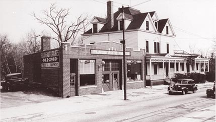
I have some old photgraphs of various locations along Springfield Ave. in 1951. I don't know how well they will "translate" through scanner and pixelization, but I'll give it a try. The first shows Flagg Auto Parts building and the old Maplewood Inn ( both gone now for a long time ) at Burnett Ave. |
Kestrel
| | Posted on Monday, June 25, 2001 - 9:56 am: | |
 |
Bobk
| | Posted on Monday, June 25, 2001 - 11:47 am: | |
Kestrel, the photo came through perfectly. Keep them coming.
Maybe the Springfield Avenue shots will be of some use when the project starts.
Thanks |
Kestrel
| | Posted on Tuesday, June 26, 2001 - 7:22 am: | |
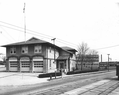
This is the old Engine #2 Fire Station - and, the Hilton Library, which was upstairs, if you can believe it! It was located on Springfield & Boyden Ave's., just across Boyden from where the new one now stands. The Public service building can be seen in the background. Note the Trolly tracks on the Avenue! |
Kestrel
| | Posted on Tuesday, June 26, 2001 - 7:28 am: | |
O-o-o-p-s! Let's try again....
 |
Dave
| | Posted on Tuesday, June 26, 2001 - 9:43 am: | |
There'll be no book burnings there!
Hey, any shots of the actual trollies?? Anyone know when they stopped running? |
R2boy
| | Posted on Wednesday, June 27, 2001 - 5:42 am: | |
What great memories this picture brings back. We used that library all the time.The Ward Home was to the left before the pool was built. The "car barns" later known as NJ Transit are next to Public Service bldg.Movies in the summer at Maplecrest Park. The 50's were fun times here in Maplewood... |
Bobk
| | Posted on Wednesday, June 27, 2001 - 8:44 am: | |
My guess would be that the trolley line would have been replaced by a bus line by @1950 based on other towns I know of. My Dad was a trolley and interurban enthusiast.
In the John Harvey postcards there is one picture of "Model Park", which was the end of the Springfield Ave trolley. The picture shows an elevated steam train (the old Erie Lackawanna?) in the background. Anyone know where this was?
Most of the other post cards show buildings or features that still exist today. This one was a puzzler to me. |
Kestrel
| | Posted on Wednesday, June 27, 2001 - 11:48 am: | |
Bobk: I'm puzzled too - maybe someone out there can answer.
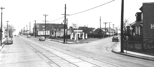
Meanwhile, here's another puzzler: Back in the 50's, there was probably less than half the automobiles that there are now around here, but there must have been 5 times as many gas stations! I'd estimate there were at least 20 on Springfield Ave. between the borders of Irvington and Vaux Hall. Here's one that stood at Laurel Ave., where the Dunkin Donut-Blimpie place is now. Probably much of the detail will be lost, but on the original photo, the sign says "Sky Lark" and the price per gallon was 19.9 cents! |
Kestrel
| | Posted on Wednesday, June 27, 2001 - 11:56 am: | |
 |
Bobk
| | Posted on Wednesday, June 27, 2001 - 1:09 pm: | |
Basically, cars got more reliable and warranties stretched out to three years, cutting down on the repair business most gas stations really made their living on. The Oil Companies got tired of delivering to relatively small customers and didn't renew the franchises. The EPA required that tanks be replaced and pollutuion insurance be carried. Thus fewer, larger gas stations.
And thanks for the picture.
Maybe Ken, who seems to really into rail transportaion can identify the Model Park postcard. |
Dave
| | Posted on Wednesday, June 27, 2001 - 2:25 pm: | |
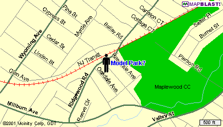
From Willfalaise1, in reference to map below.
Quote:I can't even figure out how to save this to my own computer, let alone posting it on the local history thread. But this was supposed to be my answer to the where was Model Park question. From the description in Maplewood history book that I originally saw the post card I always imagined it to be here (see little man walking), and that the postcard showed a train going from Mwood to Milburn. The terminus of the Springfield trolley comment on the card never fit this to well, though. If you could find a way to post this I'd be very grateful!
|
Dave
| | Posted on Wednesday, June 27, 2001 - 2:28 pm: | |
 |
Willfalaise1
| | Posted on Wednesday, June 27, 2001 - 2:34 pm: | |
thanks Dave! |
Bobk
| | Posted on Wednesday, June 27, 2001 - 2:43 pm: | |
Wow, you guys are incredible. The only comment I would make is that the location is in Milburn!!! |
Kestrel
| | Posted on Wednesday, June 27, 2001 - 3:12 pm: | |
Ok- Though the spot indicated on the map isn't quite on the location, I'm wondering if it was what we always called the "Maplewood Loop"- where today,s NJ Transit buses (Both, the Springfield Ave and the Valley St routes) turn around before heading back to Newark. Obviously the trolleys were the forerunners.
There used to be a tiny, rickedy, lop-sided, wooden diner or luncheonette there too. |
Bobk
| | Posted on Wednesday, June 27, 2001 - 3:27 pm: | |
Kestrel, I am sure that Maplewood Loop is the turn around point for one trolley line. However, the postcard that started this whole thing shows a steam locomotive and passenger train in the background. Unless there use to be another RR line..... |
Kestrel
| | Posted on Wednesday, June 27, 2001 - 3:55 pm: | |
OK...looking at the above map, I place "Maplewood Loop" on Millburn Ave, right at the point where the Maplewood CC. and the river come together, right? Could it be that Model Park predated and took up the ENTIRE area where there are now streets? (Oakdale,Rosedale Ave.S and others un-named on the map) If so, and if (two big ifs) the post card photo was taken from a viewpoint in Model Park that was closer to the railroad - could not that in fact, be same railroad and area? |
Bobk
| | Posted on Wednesday, June 27, 2001 - 4:15 pm: | |
Kestrel, I am not sure about that. However, the location on the map makes a lot of sense when I think about it and so does Maplewood Loop.
The trolley companies had to be franchised by the municipalities they ran through and pay for the franchise. Both Model Park and Maplewood Loop are on the border of Maplewood and Milburn. In other words, the end of the line. |
Kestrel
| | Posted on Wednesday, June 27, 2001 - 4:25 pm: | |
Bobk: I'm certain someone who knows the actual location of Model Park will read this or hear of it and respond. Also, I'm thinking that the library must have the information. I've done a bit of on-line searching, but haven't come up with anything.
Anyway, I've been home with bronchitis for the past 3 days and this message board has sure helped to pass the time away in a very enjoyable manner. Thanks Dave, Bobk, Wilfalaise and everyone...it's been great! |
Ejt
| | Posted on Wednesday, June 27, 2001 - 4:53 pm: | |
I agree with Dave's map, just place the guy a little further up to where the railroad and Ridgewood Rd meet. The underpass in the PC could now be that curvy underpass on Ridgewood Rd. |
Dave
| | Posted on Wednesday, June 27, 2001 - 5:22 pm: | |
Hey, you can't pin that map on me, Ejt: It's Willfalaise's. I'm just an innocent bystander. Honest. |
Ejt
| | Posted on Wednesday, June 27, 2001 - 5:50 pm: | |
Oh, sorry! |
Ken
| | Posted on Wednesday, June 27, 2001 - 5:59 pm: | |
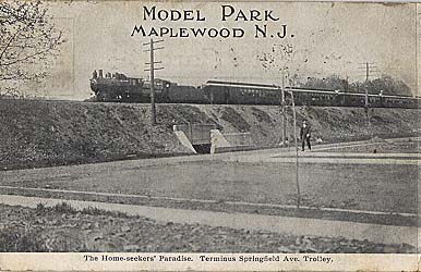
I always thought that this was on Dunnell Road going toward Baker Street by the park. The small underpass is the walk through. The caption is wrong, it is not anywhere near Springfield Avenue.
The only railroad line that came near Springfield Avenue was the Lehigh Valley, which ended in the rear of Wooley Fuel. That line continued south, through the area where the current DPW is, across Rutgers Street (where the hump in the road is), to Rt 22 in Union, where it hooked up to the Rahway Valley RR.
Ken |
Ejt
| | Posted on Wednesday, June 27, 2001 - 5:59 pm: | |
Also, I think the trolley may have gone up Cypress(the one not marked on W.'s map between Oakdale and Rosedale) due to the wide right turn it has. |
Bobk
| | Posted on Wednesday, June 27, 2001 - 7:15 pm: | |
That was my initial thought as well, because of the underpass, but somehow it just doesn't look right or make sense to have a trolley running to a railroad station. Both went to Newark.
Ken is remarkable. He doesn't post here all that often, but mention his name and he shows up. |
Ejt
| | Posted on Wednesday, June 27, 2001 - 8:17 pm: | |
There wasn't a trolley anywhere near the Mplwd Train Station. Ken is dismissing the caption.
Anyone have any idea what year this PC is from? |
Ken
| | Posted on Wednesday, June 27, 2001 - 8:41 pm: | |
The tracks were elevated in 1903, and since it looks kinda new, I would say anytime after that. |
Ken
| | Posted on Wednesday, June 27, 2001 - 8:48 pm: | |
Here's another:
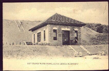
Any ideas where this is? |
Dave
| | Posted on Wednesday, June 27, 2001 - 9:00 pm: | |
Wild guess: I think that's along Rt. 46 near East Hanover/Parsippany on the westbound side. |
Pcg
| | Posted on Wednesday, June 27, 2001 - 10:31 pm: | |
Wyoming Ave. |
Dave
| | Posted on Wednesday, June 27, 2001 - 10:32 pm: | |
That's it! |
Ejt
| | Posted on Wednesday, June 27, 2001 - 11:32 pm: | |
That weird little building that's been there forever across from what is now The Top on SO Ave? |
Goodolddays
| | Posted on Thursday, June 28, 2001 - 12:18 am: | |
Eit....wasn't that weird looking building that once stood across from the old Grunning's Top site once used during WWII as a spotting observation post for air craft? |
Steven
| | Posted on Thursday, June 28, 2001 - 8:11 am: | |
That building is on the Maplewood/South Orange border on Wyoming. For an 'official' reference to this building please get a copy of Bill Hart's East Orange in Vinatage Postcards, available from local bookstores or on the major internet booksellers. |
Ejt
| | Posted on Thursday, June 28, 2001 - 10:22 am: | |
Goodold: I've never heard that but could be true. I've never noticed the building on Wyoming in Ken's PC. Is it still there? What cross street is it near? |
Kmk
| | Posted on Thursday, June 28, 2001 - 10:26 am: | |
It's a lovely little building! (They just don't build them like they used too.) I first noticed it while we were shopping for houses - too bad it wasn't for sale.
Does the image show somebody sitting on the front "porch"? |
Patty
| | Posted on Thursday, June 28, 2001 - 11:51 am: | |
Don't know the cross street, but it's maybe 2-3 blocks south of S.O. Ave. on Wyoming, west side. Some connection to the water supply? I've noticed no-trespassing signs to that effect. Imagine the building with growth all around leading up to reservation areas and you'll get it. |
Kmk
| | Posted on Thursday, June 28, 2001 - 2:43 pm: | |
It's on Wyoming Avenue, north of (and across the street from) the intersection with Cedar Lane. It is overgrown and set back a bit. |
Ffof
| | Posted on Thursday, June 28, 2001 - 4:31 pm: | |
All those steps are still there too. Makes a nice outdoor stairmaster. |
Curb
| | Posted on Thursday, June 28, 2001 - 7:55 pm: | |
If you go on ebay and search under south orange or maplewood. You can usually find somebody selling old postcards like the ones on this thread. If anybody is interested. |
Goodolddays
| | Posted on Sunday, July 1, 2001 - 11:50 pm: | |
Kestrel, are any old photos still around that show the harbor, which was located at the foot of Boyden Avenue? Many years ago I was told that section of town was called "The Harbor", because of the shipping harbor (a tail end of Newark Bay)that was located in that immediate area. |
Chrisd
| | Posted on Thursday, July 5, 2001 - 6:11 pm: | |
A little more on our little building on Wyoming: the site is indeed a pumping and holding station for the East Orange's Water Reserve, which stretches west of the reservation from Parsonage Hill Road and straddles South Orange Avenue. There's a tall water tower at the corner of Parsonage Hill and Old Short Hills Road (in Millburn) that's also part of this system. They pump the water around the reservation to the holding tanks on Wyoming (beneath that swampy field behind the little building) and from there it flows down the hill to EO. |